Plan Change 12: on its way !!!!

Plan Change 12: on its way !!!!
Growing up: Hamilton's response to Government direction for growth and the changes we must make to the District Plan (our rule book for development.)
Hamilton is growing and growing fast. In the past few years, we've seen more and more people choose to call our great river city home. We're expecting that number to keep increasing, and we need to plan now for where those people will go and how they will get around.
Central Government has reset the rules for how big cities can grow and these are broadly set out in the National Policy Statement on Urban Development (NPS-UD). Amongst other things, the NPS-UD requires cities like Auckland, Christchurch, Wellington, Tauranga and Hamilton to grow up, not just out.
To do this, Council needs to make some changes to Hamilton's District Plan (our rule book for development). This means there will be changes to the rules around how you can develop your property and your neighbourhood. For example, in some areas we'll see smaller section sizes, more apartments and townhouses and no requirement to provide car parking.
But it also means it puts homes closer to all the things we need like shops, parks and public transport. It also provides a greater variety of homes in our city, to help make it more affordable for everyone who calls Hamilton/Kirikiriroa home.
The changes set out in the NPS-UD are not optional. Council has to make changes to the Plan to reflect the new rules.
However, making those changes provides a fantastic opportunity for the community to influence what Hamilton looks like in the future, while still aligning with the Government's growth strategy.
Council knows this may impact you and your property, so Council will be giving all Hamiltonians the chance to have their say and make their mark on the new rules from Government as much as we can.
Afterall, it's our place, Hamilton Kirikiriroa!
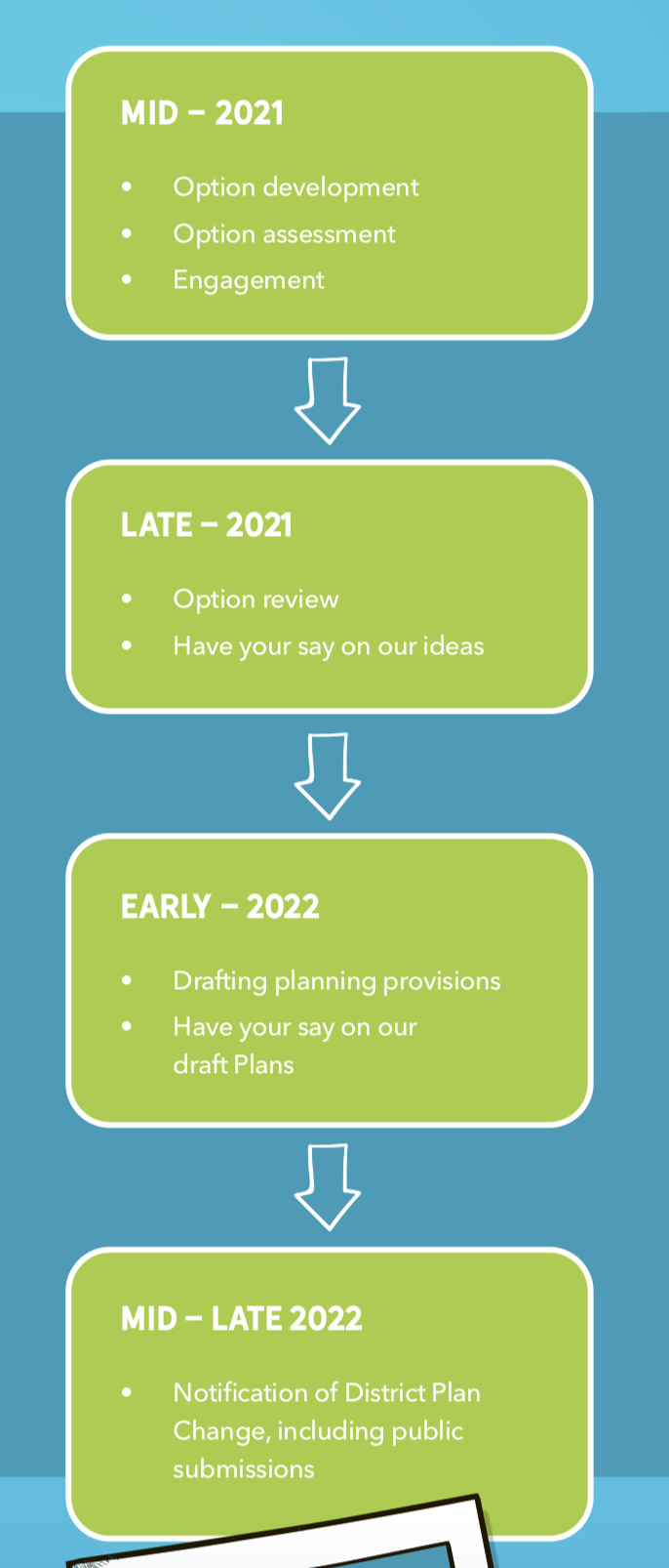
What's next?
Over the next 12 months, Council will be working with the community, stakeholders and tangata whenua to find out what's important to them and what they wish to see for their own neighbourhoods.
This will be an opportunity to express your views about what's important to you as a resident of Hamilton Kirikiriroa.
What does that mean for your area?
Government has directed a new way of managing growth in major cities across the country. Its aim is to remove some of the red tape for New Zealand's largest cities to grow 'up', allowing greater heights and greater density in locations with good access to services, jobs and amenity (like shops, parks, and public transport).
This provides for more homes, and a greater variety of homes in Hamilton, to help make it more affordable for everyone.
Council is starting to investigate what this might mean in Hamilton and will require a significant amount of engagement with the communities, tangata whenua and stakeholders before any decisions are made.
Central City
In the central city Council required to remove any building height limits. In Hamilton we already have this in the District Plan for most parts of the central city, so Council don't need to make any big changes.
However, Council expects more people to choose to live in the central city as the population grows.
Council recently refreshed the Central City Transformation Plan. This will help guide any changes Council needs to make to the District Plan to support greater building heights and more people living in the city.
Walkable catchment from the Central City
In an area around the central city that can easily be accessed by walking, Council required to enable a minimum of six storeybuildings.
Having more people living close to, and walking to, the central city will boost the vibrancy, help meet climate change targets, and let people enjoy their city in new ways. A walkable catchment supports a 20-minute city concept, where people can access everything they need without getting in their cars.
These areas will be supported by quality public transport, walking and cycling facilities, parks and open spaces and nearby to shops and schools.
The rest of the city
In the rest of Hamilton, Council required to enable greater density/building heights in areas where people can easily access jobs, shops, schools, parks and quality transport connections.
There are lots of places in Hamilton that have good access to these things, outside of the Central City and the walkable fringe areas. These areas are therefore well suited to further intensification.
Council currently investigating what those areas are and how different types of higher density housing could work well.
Area plans
In some areas already identified as having good access to public transport, jobs, shops and schools, Council is putting together area plans to help consider how these areas could be intensified.
Area plans will be created by a team of experts in consultation with the community over the next 12 months to help inform the changes to the District Plan.
There's more information about those areas below:
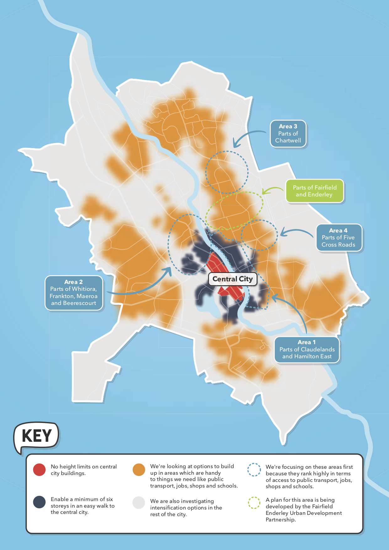
North of the Central City
This area includes parts of Whitiora, Frankton, Maeroa and Beerescourt.
Why north of the Central City?
- Only a 10-minute walk from the central city, this area is an attractive option to live as its close to work and entertainment options. It helps support a vibrant central city!
- It supports a more efficient city that relies more on public transport, walking and cycling and has benefits for the environment. Most jobs in the city can be accessed from this location by a 20-minute bus ride.
- It's supported by great open spaces nearby including the West Town Belt, Waitawhiriwhiri Gully and Waikato River. As well as facilities like FMG Stadium.
What will it look like in the future?
We're only just starting this work, so nothing is set in stone. However, here's what we might see:
- Areas closer to the central city, Te Rapa Straight and Ulster Street could have greater heights and densities than those further away because of their location and transport connections.
- Increasing quality of walking, cycling and public transport to support these communities and give current and future residents more choice about how they get around the city.
- A greater range of housing options such as apartments, townhouses and duplexes.
- The West Town Belt and the Waikato River would remain important features in this area.
Eastern Hamilton
This area includes parts of Claudelands and Hamilton East.
Why Eastern Hamilton?
- It is located within walking distance of the Central City, which will be a significant catalyst for transforming the area.
- A lot of urban intensification is already taking place here, particularly around the Hamilton East shops which is already a suburban centre.
- One of our oldest neighbourhoods, it's known for its eclectic, nostalgic ambience, central location and genuine mix of commercial, residential and leisure activity, which makes for an attractive and vibrant area. With careful planning this can be reinforced as development happens.
What will it look like?
- There will be more opportunities for high quality mixed-use development (shops and offices on lower floors with apartments above) and growth of the business area on Grey Street.
- Enhancing gullies and connections to the Waikato River, parks and reserves to form part of a green network that connects people and provides places to play.
- Areas with heritage and historical character will be identified.
- Properties closer to the central city, business, parks, schools and community activities are likely to have more dense development enabled compared to those further away.
Chartwell
This area includes parts of Chartwell centred on the shopping mall.
Why Chartwell?
- Chartwell is a recognised community node and focal point for the wider region. It offers a diverse range of retail, entertainment, and jobs and is close to parks and schools.
- It is highly accessible through walking, cycling, frequent public transportation routes, key roading connections and the future Waikato Expressway.
- It's a key part of the Eastern Pathways programme, which aims to create better walking, cycling and public transport connections for schools in the area.
What will it look like?
- Our aim is to create an area that provides opportunities for walking, cycling and public transport, has a wider range of housing options while retaining a sense of identity and community. The shopping mall, existing gully network, connected roading network and well-developed parks would remain as key features of the area.
- There will be the option for increased building heights and density in the areas that are most accessible. For example, around the shopping mall the building heights and density could increase potentially up to six storeys and decrease gradually to around three storeys further out from the shopping centre.
Five Cross Roads
This area includes parts of Five Cross Roads.
Why Five Cross Roads?
- The area is already zoned for higher densities and building heights.
- Kāinga Ora own a lot of properties in this area. They are already looking at opportunities in Enderley and Fairfield and it makes sense to work together in these areas.
- Significant investment in public transport, pedestrian and cycling facilities is already planned, including the Eastern Pathways programme.
- It is highly accessible and located close to parks, schools and retail linked by key transportation corridors of walking, cycling and frequent public transportation routes.
What will it look like?
- Similar building heights to the new developments we're already seeing along Fifth Avenue.
- Greater urban design direction and control will improve the look and feel of the neighbourhood.
- Better walking connections through the neighbourhood and around Five Cross Roads itself.
Fairfield and Enderley
A plan for this area is being developed by the Fairfield Enderley Urban Development Partnership. Council and Kāinga Ora – Homes and Communities will work alongside iwi, mana whenua and the Fairfield and Enderley community to create a plan for the area. This is a separate piece of work that will inform the District Plan change next year.